
To continue my caving story, I’d like to borrow the words of La Venta exploration team in their study in 2011 titled, Chronicles from the empty mountain, referring to St. Paul Mountain and I quote:
“Those who have never seen the corroded tropical karsts would have a hard time picturing that terrain in their minds. The landscape is nothing but a series of vertical limestone blades, at times simply leaning against each other, sharp as knives and too far from each other to be passed by jumping over them. In some areas, walking becomes an exceedingly slow business, requiring extreme concentration: tripping would have disastrous consequences.”
One month passed rather quickly – and we were soon preparing to continue our spelunking adventure in the St. Paul Mountain range. I have been looking forward to this adventure because I will be able to see the rest of the known caves in Mt. St. Paul – what could be more exciting than achieving a dream?
La Venta exploration team described Mt. St. Paul as “It is a mountain with blurred edges: there is no physical surface defining its edges. One gradually moves from “outside” to “inside”; its topographical representation is merely a convention.”

Most of us in CCTA resides nearby the Barangay New Site. Elsie’s house was the meet-up place. While we were waiting for others to arrive, we packed our lunch for later in the mountain. In the list were the usual food stuff as we had before except this time we had simmered pork, another favorite in our kitchen.
We started our trekking from their house. The trek was a bit dragging. Even though I was really excited to see the caves, I think I was still waiting for the adrenalin to kick in, or maybe because I have learned that the first destination will take a little while to be reached.

For us to get to the area, we crossed the alluvial plain immediately to the south of Cabayugan village. I remember one time during the rainy season, this field got really submerged under floodwater. All the planted palay and vegetables were gone and the area was a covered by a dark cream colored water.

As we neared the approach to the climb, there is a little stream with a very weak log that serves as a footbridge – but I opted to wade in the water. This stream creates the marshy ground at the edge of the massif.
At last, the familiar limestone cliffs were finally in front of me!

The St. Paul Mountain range is 1028 m high. It is a karstic area and made up massive grey limestone covered by lush tropical rainforest and getting thinner as the altitude increases. Three vegetation types can be found in this 22,000 hectares protected area: coastal forest, lowland forest, and karst forest.
Facing the first ascent, I told myself to wake up and be alert. Remembering my promise to my mom that I will be back home safe and sound after this adventure. No broken bones, no cuts, nor bruises.
This time, the group decided that each of the ladies will be paired with gents to help us in the climb and as an extra precaution for us who are not familiar with the route – actually, there was really no established trail to the caves. Efren was my co-climber. He is one of those who also had frequented the rocky mountains to haunt and collect edible birds’ nests. They were teasing us that this will be our training to become an official nest-gatherer. I took that as a challenge. Compared to nest-gathering in El Nido, what I was going to do in the St. Paul karst mountain that day was riskier. In El Nido, nest-gatherers have ladders and climbing equipment. As I have mentioned in Part I, we didn’t have proper safety equipment. Aside from the skilled and experienced local climbers as our partners and our determination, the most reliable equipment we had was a rope.

I can’t remember how many turns and climbs we did but I have noticed that the knife-edged limestone cliffs we were stepping and climbing on are sharper and more pointed compared to the ones we’ve climbed on before.
Because of the nature of the terrain (or lack of it, since it was mostly rocks), there were no water sources beyond the first hour of the hike. The hot sunny day and the sweat-inducing climbs made me so thirsty.
After 3 hours and a few more panting from the numerous ascent and descent by the edges of the precipitous cliffs, we saw the entrance to Tagusan Cave. Luckily, we didn’t lose our bearing this time.
Tagusan Cave
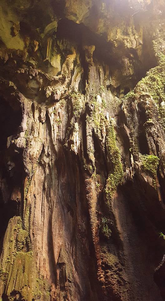
Tagusan Cave’s wide gaping entrance is about 10 meters high. Going inside the gallery which is about 25-40 m wide and 25-30 m high one can find large and degraded columns and stalagmites.
It’s like a natural passage with a distance of 500 meters long that serves as a tunnel. This is why the villagers called the cave as Tagusan – directly translated to “through”.

Each one of us said our respect, “Tabi tabi po” as we entered the Cave. We always did in every cave or dense forest that we were in. While taking a short rest in Tagusan, my companions used of the time to strike poses after poses. One climbed up an enormous tall stalagmite that resembles like a leaning post. While I was taking notes of what’s inside the roomy tunnel I noticed that the inside is mostly dry but you can really feel the breeze coming in from the other end.
On to the next cave with a few more twists and crawls, pulls and stretches on our way through this spelunking adventure with our experienced guides. When there is a need to stop, I took delight in the view down below.
Horror Cave
I was so glad upon reaching Horror Cave – it has an active course of water! That really amazed me. The presence of water made me more excited than getting crazy about exploring what’s the inside of this cave. The first part of the climb was terribly hot and the sound of a lazy flowing stream was really a strength-booster. I was one of the firsts who lined-up to take a shower under the dripping water on the edge of one of the rocks at the entrance of the cave.
According to the La Venta Exploration, Horror Cave’s entrance is at 200 m asl. The cave was very dark. We can hardly see the inside with what light we have from the flashlight. This is the very reason why the locals named it as Horror Cave.
As we were enjoying our lunch under the trees, I compare the cave’s portal to that of smiling lips; opening at 4 m but is stretched at 20 m long. Looking like a mouth swallowing the water going through its throat. I wonder where does the stream go. Would this Cave swallowed us if we did go inside its bowels?
With what little time left before darkness sets in, Dario suggested we must move on to our next destination to set camp for the night.
Memory Cave
It was past 1500H when we set off to the next cave. We seemed to be racing against each pair to reach Memory Cave the fastest we can as it will be more difficult to keep everyone safe if we get stuck in the forest when night befalls.
The first part of the hike to Memory Cave was a seemingly never-ending downward slope. It was a terrible challenge for the legs to fight the pull of gravity in order to stay on the downsloping rocky ground. I think this was the point that we were crossing one contour of the mountain range from one to another.
And then it is time to climb again. At this part, we use for the first time our rope to climb on to the entrance of Memory Cave. Efren was so supportive of me lending his shoulders for me to step on, pulling my whole weight, grabbing my hand or providing his foot as an extra ledge for me to reach the next ledge or cliff.
Sweaty and all but I had finally made it to the top. I was so thirsty and sticky that I’ve already missed the stream in Horror Cave.
Memory Cave is at an altitude of 360 m and has a length of <600 meters. Its steep opening is really huge which I think around 30 meters wide and 12 m high. The wall of the entrance is chalky most probably due to calcium carbonate which characterizes the St. Paul Mountain range.
We didn’t go inside the cave when we got there. Dusk had set in and we were all so exhausted battling our way up. No one even bothered about eating instead each looked for his own nook to rest in through the night. We just nibbled on biscuits and bread as we were laying on the ground ready to sleep.
It was so difficult to get comfy because of the downslope entrance of the Cave where we settled in. Plus there was no flat ground under the cave ceiling that is wide enough for all of us. There were columns and other oddly-shaped speleothems here and there. I just fought off the discomfort by indulging in the view of the sky partly covered by the tree canopy.
The following morning, I woke up with sore arms and legs. Nevertheless, I was still beyond elated with what I’ve accomplished so far. Never did I imagine that I will be able to climb these mountains which I used to just watch from afar – and no bruises yet! It was still so hard to believe that I was communing with nature embracing the immeasurable beauty of her jewels hiding in the midst of its forests.
After our breakfast of noodles, coffee, and bread we were ready to continue on with our bold exploit and started exploring the inside of Memory Cave.
Few steps from the entrance, we began to descend and reached a large gallery which is impressively extensive – with widths of 25-30 m and heights of 30-40 m.
Being in this dimly lit cavern, I thought of us making our own treasure-hunting film, the likes of Indiana Jones or The Mummy. I’ve learned from my group that Memory Cave was once used as a graveyard by the indigenous people living around the St. Paul mountain. That really sent some chill factor in my nerves instantly producing uncanny images in my mind. I was just so glad I didn’t stumble on any tomb or a mummy inside.
After our probing inside, we got ready to trek to the last cave in our list.
Layag Cave
The entrance to Layag is only a few dozen meters above the entrance of Memory Cave. The hike was not difficult but the ascent to the mouth was for me the most ambitious among all the caves we’ve visited. The guides I think really saved the best for last.

The portal of Layag Cave is situated at the level of a narrow balcony between two tall cliffs. With just an ordinary rope to climb on, getting into this balcony is physically demanding, as it required to climb a vertical cliff. Some in the team opted to stay below but I was one of the four who pursued to climb up. With Efren’s assistance, I successfully got on the top.
The name Layag was given by the local to this Cave because of a big rock by its entrance that is shaped like a sail. In the balcony, Layag’s large entrance is raised over an accumulation of collapsed blocks over 15 m high. With the width and height of the gallery, I imagine a Romanian abbey – wide and tall. I heard flapping of wings. It seemed that the colony of bats favored hanging around in this Cave than in the others.
We didn’t go any further ahead since most were waiting for us down below. Manong Enteng told me that there is another portal, big and wide, some meters from the gallery. The opening is directly facing out from the cliff towards the Cabayugan plain. I would have wanted to see that but we had to go back to the ones who stayed behind.

Efren asked me who else was up there. I said no one. I was the last one who climbed down. He told me, he saw a female behind me while I was getting ready to descend on the rope. I was chilled to the bone because there wasn’t any other female from the group who went up. Emily tried but decided to stay in one of the ledges almost halfway to the top. Could it be Mother Nature that walked with us in the entire feat?
After regrouping at the foot of Layag Cave, it was time to go back down to the village. I bid my bye to the extraordinary world behind me and thank the forests and caves for letting us in their abode.
Orang Falls
Going back to the village, descending from the sharp edges of the mountain, weaving through thick forests and once again we set foot on the plains, we passed by Orang Falls.
Orang Falls got its name from the freshwater shrimps that the locals catch from this little body of water.
We decided to eat lunch and splurge on bathing in the crystal clear water – something that we’ve missed the past days. When everyone started to get cold from swimming in the stream, we finally decided to head to Manturon.

What a joy! Everyone made it back in one piece – on our ordinary slippers. I should of congratulate the producer of the slippers because the pairs we had successfully protected our soles from the sharp blades and points of limestone.
Back in Sitio Manturon, while I was lying on a bamboo bench in our Nipa hut my mind still drifted at the sights that I had witnessed. I was still left awestruck by the power of creation, and mother nature’s wonders as our 2-day spelunking adventure came to an end. This will probably be one of the most treasured experiences that I would do again given a chance. And it would undoubtedly remain with me for long.
